The Final State of the Union
Last September, at the UN Climate Summit in New York City, President Obama committed to work with partner nations to empower local authorities to better plan for the impacts of severe environmental changes such as drought, glacial retreat, flooding, landslides, coastal storm surges, agricultural stresses, and public-health-relevant challenges. As part of this commitment, he announced an interagency effort to, within one year, release higher-resolution elevation data for regions around the world – beginning with Africa. Datasets for the Caribbean, Mexico, and other regions have subsequently been made freely and publicly available.
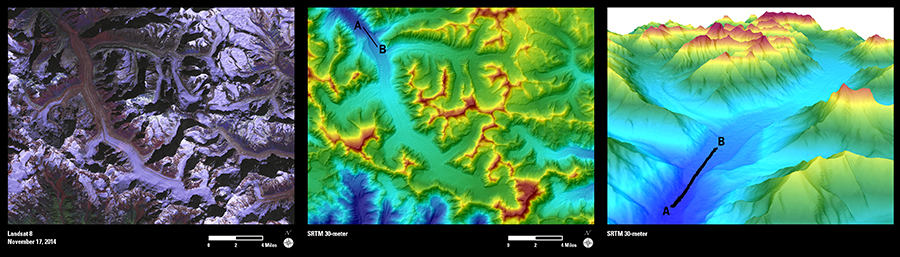
Today, the Administration announced the release of the next tranche of higher-resolution elevation data for India. Until now, these elevation data for India were freely and publicly available only at 90-meter resolution. The datasets being announced today resolve to 30-meters and can be used to better assess and monitor the impacts of sea-level rise, conduct environmental monitoring activities, and support local resilience-relevant decision-making. These datasets are being made available on the U.S. Geological Survey’s Earth Explorer website.
Accurate information about elevation is fundamental to decision making at local and regional scales. The height of land, for instance, determines how and where water will flow, where there will be coasts, and what shape those coasts will take. Land terrain, in part, also determines where plant and animal species live and thrive.
The National Aeronautics and Space Administration (NASA) and the National Geospatial-Intelligence Agency (NGA) worked collaboratively to produce the data being released today. With a commitment from the Secure World Foundation, USGS, the National Oceanic and Atmospheric Administration (NOAA) and NASA plan to offer online training and regional workshops to further enable users to take advantage of these data resources.
The release of these data align with today’s broader announcement that the Administration will jointly undertake, with India, a partnership on climate resilience that will aim to: downscale international climate models for the Indian sub-continent to much higher resolution than currently available; assess climate risks at the sub-national level, work with local technical institutes on capacity building; and engage local decision-makers in the process of addressing climate information needs and informing planning and climate-smart development
Citizens around the world are experiencing the impacts of climate change. Today’s announcement aligns with the President’s Climate Data Initiative and the Administration’s wide-ranging efforts to empower people and communities at home and abroad with the information and tools they need to plan for the future in the context of a changing climate.
John P. Holdren is Assistant to the President for Science & Technology and Director of the White House Office of Science & Technology Policy.