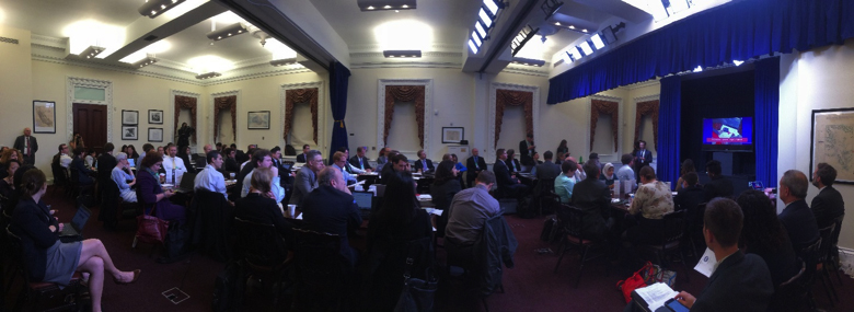
Last week, citizen cartographers joined the White House Office of Science and Technology Policy and Office of Digital Strategy for the first-ever White House Mapathon.
In just three hours, more than 80 mappers edited more than 400 roads and 1,000 buildings in OpenStreetMap, and collected power outage info on 152 power utilities. The mapathon focused on three main projects: humanitarian mapping efforts, mapping U.S. parks, and power outage mapping.
The day’s work is already showing huge benefit to these projects. For example, the Department of Energy committed to working with the Red Cross to continue open mapping national power outage information with the goal of having complete data for the entire country. And the Department of the Interior, along with the Department of State's MapGive program, is looking to hold more mapathons and keep momentum up with release of additional data sets.
At the event, participants came together in support of open mapping initiatives. Open mapping, or crowdsourced mapping, describes how millions of people are using a wiki-like approach to contribute to maps of the world and creating shared geo data layers. Recognizing the power that projects like these have to educate, engage, and empower the public to apply their curiosity and contribute their talents to a wide range of scientific and societal problems, President Obama called on Federal agencies in 2013 in the Second Open Government National Action Plan to accelerate and scale the use of citizen science and crowdsourcing projects.
Found the two youngest star mappers at the #WHMapathon--Charlie, 12 & Mia,14 with their amazing teacher @cogunshakin pic.twitter.com/Xm5UAJSU25
— Megan Smith (@USCTO) May 21, 2015
Governments can engage smart, innovative, and resourceful citizens to support urgent efforts — nothing demonstrates this better than the recent OpenStreetMap response to the Nepal earthquake. Through remote mapping and shared satellite imagery, citizens, government, the private sector, and academics are demonstrating the power of collaborative, open innovation, helping to solve challenges, create opportunities, or respond in the face of tragedy such as the Nepal Earthquake. In the immediate aftermath, more than 4,000 people mapped and edited almost 30,000 segments of road and more than 243,000 buildings, totaling more than 4.5 million edits.
Crowdsourcing and open mapping can be applied to a vast range of topic areas. At the Mapathon, participants collaborated to add to the Nepal map and also mapped:
- The Peace Corps’ public health programs in Botswana.
- Sustainable, disaster-resilient development in the Philippines.
- Trails and facilities in parks for the Department of Interior’s Every Kid in a Park initiative.
- Details on power companies’ service areas and outage information with the Department of Energy’s Power Service Area Mapping project.
Mappers also heard about additional opportunities for mapping projects related to:
- The Police Data Initiative, where contributors can identify, classify, and map available data sets from law enforcement agencies around the country to increase transparency and build trust between law enforcement and their communities
- City SDK (software development kit), where mappers can identify innovation spaces and other collaborative workspaces within communities for the public to foster science, technology, engineering, arts, and math for young people and help workers learn new job skills.
Crowdsourced mapping projects have the potential to help governments identify opportunities to improve services and to help the public find resources to enhance their lives. The private sector can also harness the economic value of geospatial open data in the rapidly growing mapping and mobile location industry. For young people, crowdsourced mapping is a zero-barrier entry way to learn in-demand technical skills.
There are so many issues that could benefit from technologists and geographers coming together to make maps. Doing so in a collaborative way, enabled by the internet, open to anyone, represents the best of government and citizens around the world working together.
We’d love to hear your ideas for future commitments and collaborative, open mapping projects. Share your ideas and how we can work together toward them in the future using #WHMapathon.
Megan Smith is the U.S. Chief Technology Officer. Mikel Maron is a Presidential Innovation Fellow at the U.S. Department of State.
Learn more:
- Citizen Science is Everywhere, Even the White House (OSTP Blog)
- More details on the efforts to empower students through citizen science announced at the Science Fair (March 2015)
- Citizen Science Contributes to Advances in Scientific Understanding (OSTP Blog)
- Designing a Citizen Science and Crowdsourcing Toolkit for the Federal Government (OSTP Blog)
- Second Open Government National Action Plan (2013)
- Federal Community of Practice on Crowdsourcing and Citizen Science
